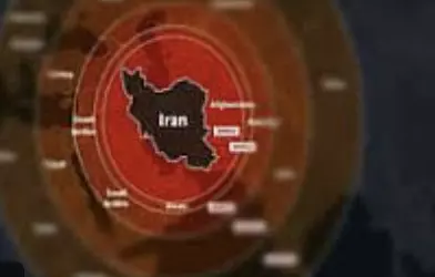
The Israeli Defence Forces (IDF) have issued an apology after releasing a controversial map that inaccurately depicted Indian territories. The map, intended to illustrate the range of Iranian missiles, wrongly showed Jammu and Kashmir as part of Pakistan and Northeast India as part of Nepal.
Responding to the criticism, the IDF clarified, “This map fails to precisely depict borders. We apologise for any offence caused by this image.”
The controversy comes amid intensifying conflict between Israel and Iran, following Israel’s airstrikes on Tehran targeting Iran’s nuclear sites. In retaliation, Iran launched missiles and drones targeting Israeli cities.
The incorrect map, shared during such heightened geopolitical tensions, drew attention not only for its military implications but also for its diplomatic insensitivity.